DAY 26 – THE KINGS CANYON RIM WALK…
My turn to
have a day at home to chill out and catch up on my journal, this blog and all
the photos we have been taking. The
others were going to do the Kings Canyon Rim Walk, but I knew that I would have
trouble with it with my hip and feet, so opted to stay home as the walk was
over 6 kms long and over a lot of rocky terrain.
It was good
to have a day off, I caught up with everything, as well as giving the van a
good clean and getting a heap of washing done..


The others
had a great time and really enjoyed the walk, so I am going to let Steve
comment about their morning on the track….Kathy, Ian & I started the Rim
walk at about 8:10am with a steep climb for about 100m (very well stepped for
walkers – in fact the whole track was well signed). I carried my backpack with
water and nibble’s, two walking sticks, my iPhone and the SLR camera. So
remember the trip took much longer 4 hours – at least it gave Ian & Kathy
breaks. Anyway, the steep climb was nowhere near as gruelling as Uluru. About ¼ the length. Once reaching the top (~8:34am),
Kathy & I managed 1 bar of 3G on our phones, so I quickly got a message to
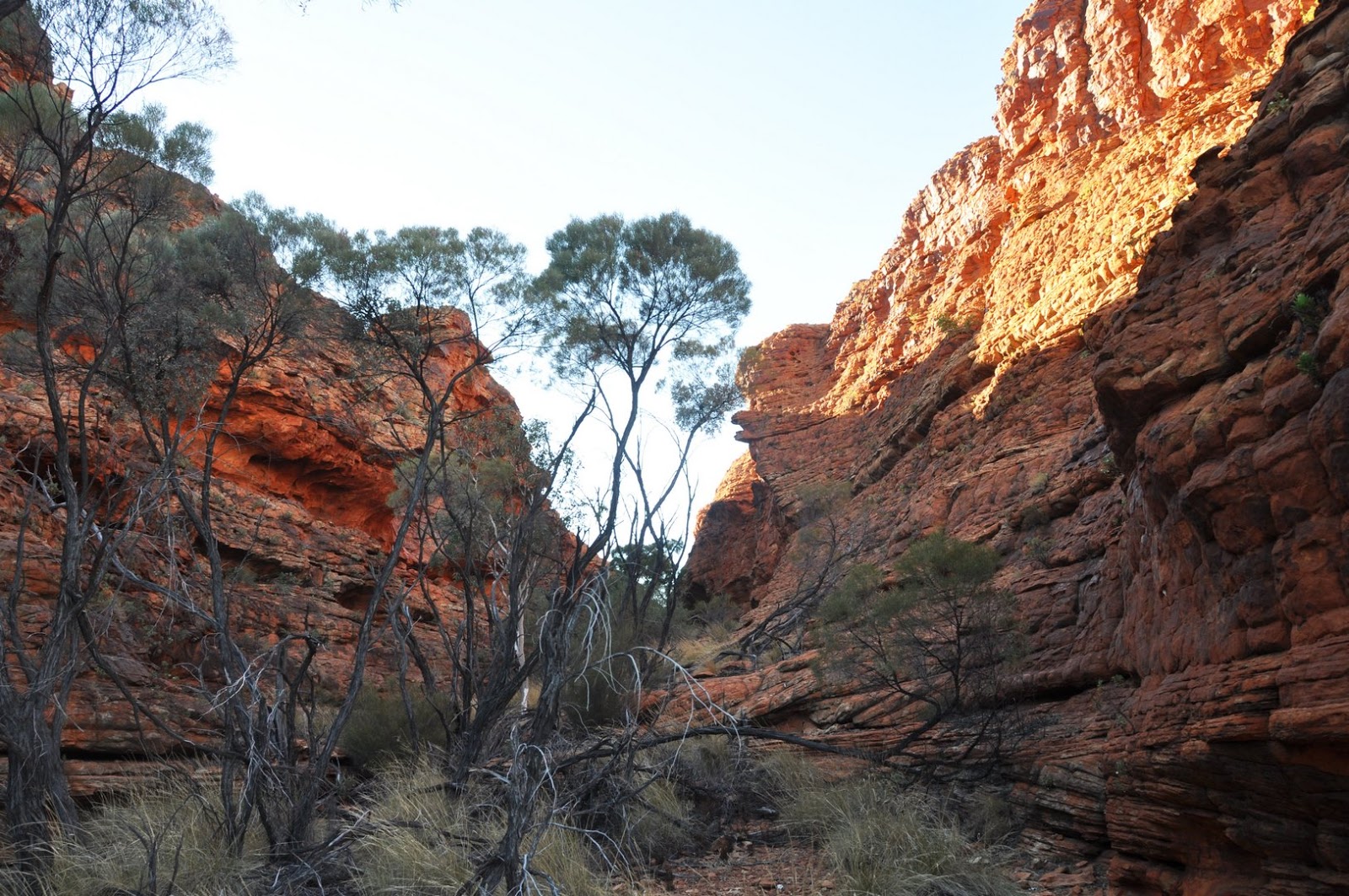
Sarah and Chloe. We came across the cliffs of an adjacent valley and the Lost
City that towered over us as if we were in its streets. The formations
comprised a finer lighter sandstone with horizontal layers. We even came across
some layer evidence of ripple action due to the waters that shaped the sand. We
came across a cliff from which we could see down the valley and the opposite
seemingly plaster rock face (sandstone) where the sun accentuated its features.
Of course, it gave me the opportunity to test my cooeeing skills and the echoing
properties of the canyon. The first was OK; however, the next echo after
crossing Cotterill’s bridge at Cotterill’s Lookout was cool with two echoes. On
our return from Cotterill’s Lookout, we met John and Barb, who were starting to
feel it, heading to the lookout. Most of the track was up and down with level
sections (both Ian’s & my cup of tea,
excuse the pun it was right up our alley) and engulfed with weathered coloured
cliff faces. Many forms of plant life found a way to survive in this
unforgiving arid landscape. Our first signs of life was the Wiggy Wagtail. We
walked on to the Garden of Eden (the upper reaches of the Canyon where there
were some steep steps down and up the other side. I took the 25-minute walk
down to the pools, which were very clean and placid. A gentle cool breeze
wisped across the waters. As the signs and adverts indicated, there were a
wider variation of plant life here. The water hole had been gouged out between
a large solid rock upstream and the right-angled bend in the creek bed. When I
returned, of course John and Barb had caught up, so we all proceeded together
meandering the sandstone trail. Over the other side of the canyon, the other
side of the gorge gave a different perspective on the coloured cliff face. If
lit by the sun it would have been even more vibrant. There were warning signs
the whole way re cliff faces. We were told there was a fatality the week before
and the full circuit had been just opened this day. I offered Barb an extra
walking stick, which was received very thankfully and made it a little easier
to manoeuvre the rest of the track. This walk was worthwhile and challenging
for all ages. It was slightly easier than The Olgass 7km walk and took us
~4hrs. All (nearly) were buggered by the end, but loved it. Well done to Barb, John, Ian and Kathy. It was great to share this with friends for a change.
Let the photos tell the story....


Would they do it again... Yes in a heartbeat....
One of the best walks so far these holidays...
Let the photos tell the story....


 |
| Love this photo of the bird in flight |


 |
| We did it.... |
One of the best walks so far these holidays...


0 comments:
Post a Comment